Texas Winter Storm: Latest Forecast, Impacts, and Safety Alerts
Temperatures are expected to plummet significantly as a Texas winter storm is expected to wallop Houston this weekend. The Arctic front is forecast to sweep across Southeast Texas beginning Saturday, bringing a rapid temperature drop, likely freezing rain and sleet and a heightened risk of icy roads and bridges through Sunday; residents and travelers should prepare for hard freezes and hazardous travel conditions.
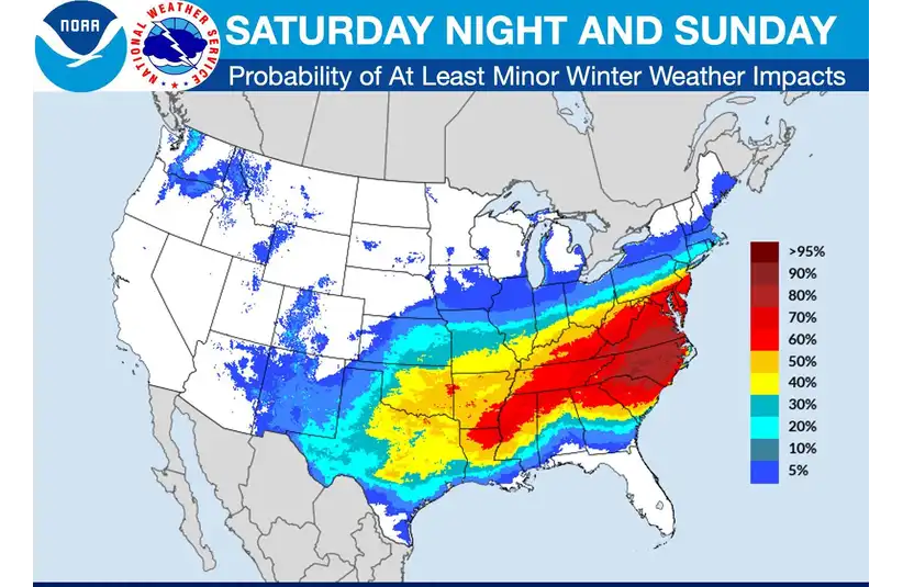
What’s Expected With Texas Winter Storm
Forecasters say a strong winter storm will push an arctic cold front into the Houston region on Saturday, ending a mild, mostly cloudy week and turning rain into freezing precipitation by evening. The front is expected to bring very cold rain, sleet, and the potential for freezing rain and icy roadways Saturday night into Sunday, with light snow possible in some areas early Sunday and hard freezes following behind the system.
CenterPoint Energy and Entergy Texas have issued preparedness notices and said crews are taking steps to protect infrastructure ahead of the Texas Winter Storm. CenterPoint’s emergency operations team said it is monitoring the model and preparing crews statewide. Don Daigler, CenterPoint’s Senior Vice President, Emergency Preparedness and Response, released a statement saying, “We continue to diligently monitor the evolving weather forecasts across the communities we serve in Texas ahead of this weekend’s potential winter weather.”
Background and Who Is Affected
The Texas Winter Storm threat comes amid heightened sensitivity to winter grid and infrastructure risks after the 2021 statewide outages. The Electric Reliability Council of Texas (ERCOT) and other operators have been monitoring forecasts and preparing operations plans. The agency’s website reports, “ERCOT will continue to deploy all available resources to manage the grid reliably and coordinate closely with the Public Utility Commission, generation providers, and transmission utilities.”
Southeast Texas, including the Houston metropolitan area and counties north of the city, faces the greatest near-term risk for freezing rain and icy roads late Saturday into Sunday. Short-term impacts include slick bridges and overpasses, hazardous travel, power and gas service stress and multiple nights of subfreezing lows; some locations could see lows in the 20s for up to four nights following the front.
For safety, it is urgent for residents in Southeast Texas to check road conditions before travel, limit nonessential trips and follow local advisories. ERCOT has been coordinating with utilities and state agencies. Although efforts are being made to reduce outage risk, the potential for localized outages and service interruptions rises when temperatures plunge, and wind chills intensify.
Other Potential Effects of the Texas Winter Storm
Short-term disruptions to commuting, deliveries, and outdoor work are likely. Prolonged subfreezing temperatures can strain water systems, agriculture, and vulnerable populations; local officials have mobilized emergency resources and have prepared accordingly.
Officials are continuing to monitor model updates and will refine timing and impacts as the event approaches. For now, the confirmed forecast and utility preparations frame the immediate public-safety priorities for the Texas Winter Storm this weekend. Due to the severity of the weather, along with the combination of freezing rain, a rapid temperature plunge, and prolonged subfreezing nights, has prompted swift, active early action from state agencies, utilities and officials.